Finding snow in Texas
Day 1 – Travel day
The night before our trip, North Carolina was forecasted to receive snow and ice. Our part of the state notoriously does not handle winter weather well, so I was worried that there may be flight delays or cancellations. Luckily, the weather was mild with roads blanketed in a light dusting of snow. We had an uneventful flight to El Paso, Texas. It’s always a mystery what car rental we will get when we show up at the counter, and this time it was a Kia Soul, a compact car as requested. (Although, we did end up really liking the minivan in Montana!)
Once we ventured out of the airport, it was a bit overwhelming being in a new city. First, we went to Walmart, which was packed on a Saturday night. We bought groceries and then went to a nearby shopping mall to pick up a quick dinner before our 2-hour drive to Carlsbad, New Mexico. Cody did well navigating these new roads. The drive was mostly spent on a two-lane highway with no center median. It was unsettling to see the headlights of huge trucks zoom past us, inches away, at 90+ miles an hour. We also had a mandatory stop at a border patrol station where the officer asked us if we were US citizens before we could continue on our way.
We couldn’t see much of the landscape at night, only the shadows of the mountains looming around us with the city lights illuminating the base of these mountains. The location of our Airbnb was very remote and a bit creepy. The directions involved us driving past “Slaughter Canyon,” to the right of a deserted fire station and following dirt roads for about 2 miles, before finding our abode for the next couple of days.
Day 2 – Guadalupe Mountains, McKittrick Canyon


When he walked outside our Airbnb the next morning, we could see the entire 40 mile Guadalupe mountain range laid out in front of us! Our first day would be venturing into Guadalupe Mountain National Park. William Pratt, an oil geologist who constructed his cabin in McKittrick Canyon, was instrumental to the establishment of this park; he donated 5,000 acres of land to the National Park Service in 1963, which lead to the creation of the park in 1972 (1).
We checked in with the ranger at the visitor’s center, telling him that we had aspirations of summiting Guadalupe Peak, the highest point in Texas at 8750 feet above sea level (2). He cautioned us that the snow was up to 8 inches deep in some areas of the trail, with ice and sub-zero windchill closer to the peak. As we were speaking, there was an active rescue mission where they were trying to find a hiker who was lost on the mountain overnight. This was much more than we bargained for, so we decided to stick to the lower elevations instead.
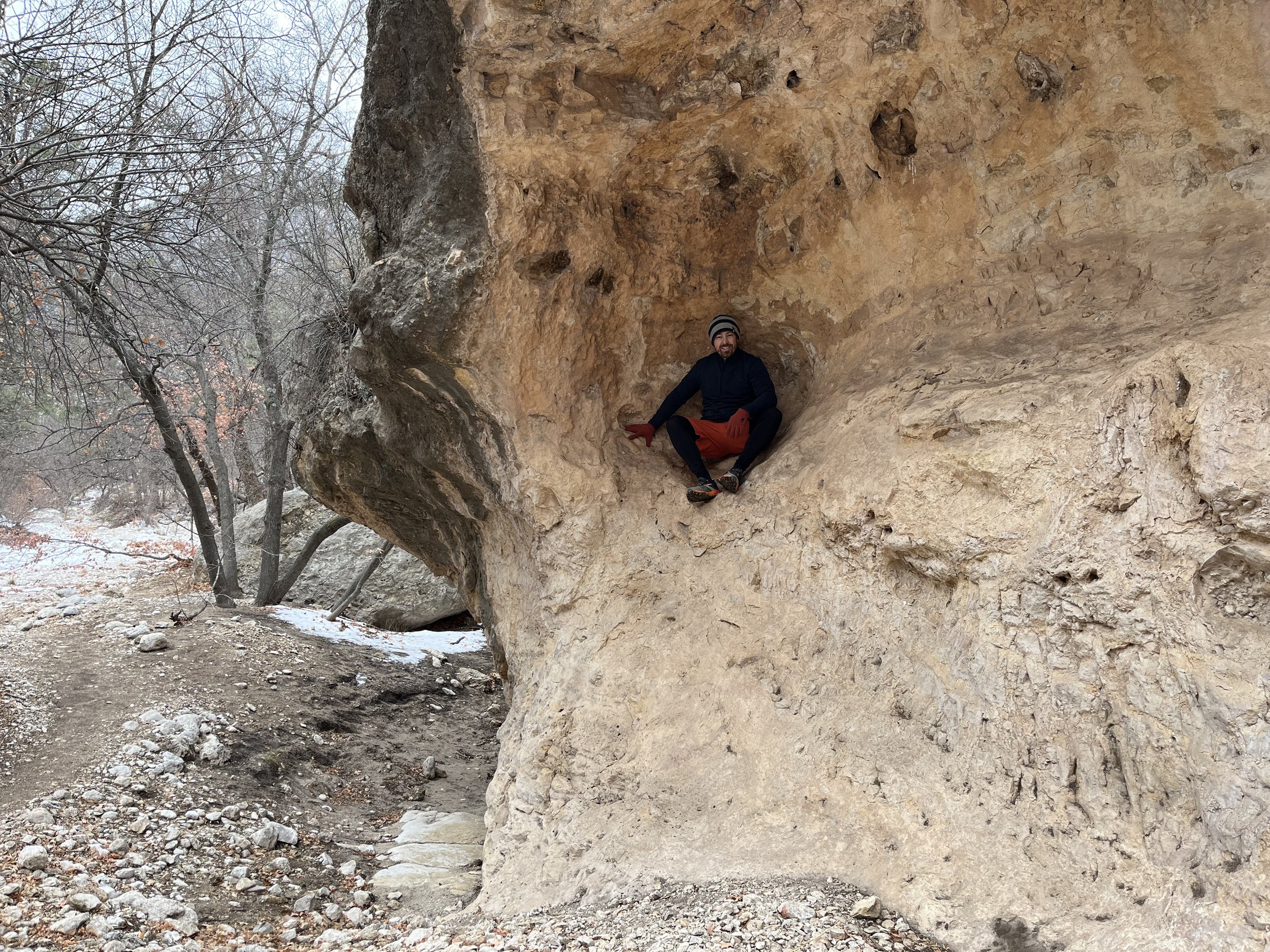
We decided to go to the McKittrick Canyon trail, which was relatively flat, about 7 miles out and back. There were patches of snow and ice on the trail, matched in their color by the smooth white limestone rocks of the dry riverbeds. The beginning of the trail is through a desert landscape, but as you venture further along, the vegetation noticeably changes to more grasses and deciduous trees. Continuing through the canyon, we came to a spot called “The Grotto”. It is an open cave with bulbous rock hanging down from the ceiling, like icicles, and seemingly sprouting from the ground. We stopped here, resting at a stone picnic table to eat lunch.
On our way back, we decided to make a small snowman to show our nephew, B. As we started on our little creation, a couple passed by and started clapping with excitement that we were building a snowman. They were visiting from Chicago, and apparently snowmen enthusiasts. Without asking, they immediately helped us forage for accessories, picking up the smallest limestone rocks for its eyes and even finding twigs and leaves for its arms and hair.
On every trip, we look for pressed pennies to add to my collection. This brought us to a gift shop in the town of Carlsbad. I always feel embarrassed asking the store clerks for change to get a 51-cent souvenir, however, they are always obliging. This man even asked me if I preferred the shiny or dull pennies to get the best press. We learned that there was a misspelling on the pressed pennies here (mountain is spelled “mounatin”). We had dinner at a Mexican restaurant called El Charro (I had a pork dish with rice and beans. Cody had a steak quesadilla). We also went to the Pecos River Flume, a concrete structure that was built in 1903 that supplies water to the area for irrigation.
Day 3 – Carlsbad Caverns and Devil’s Hall
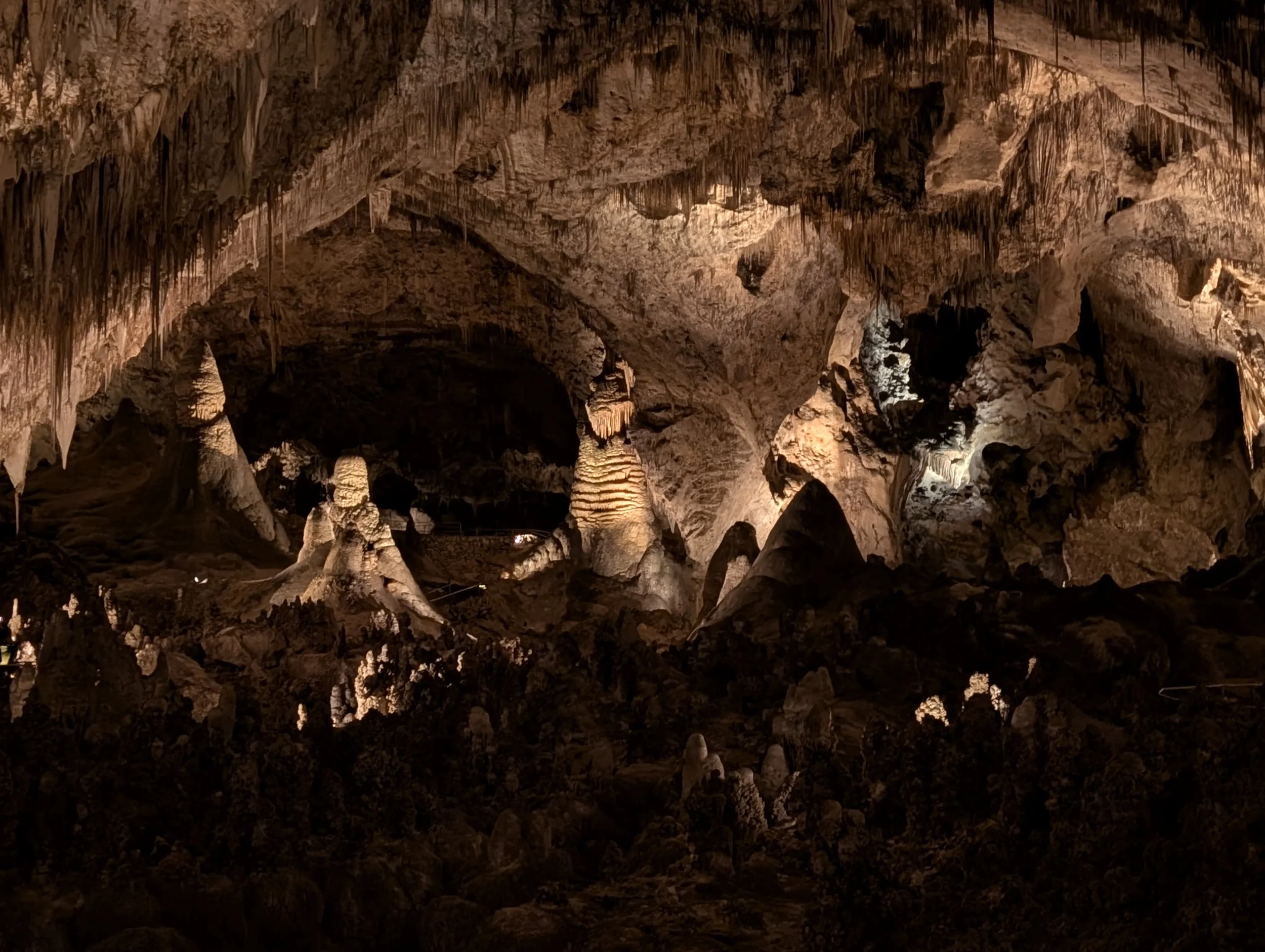
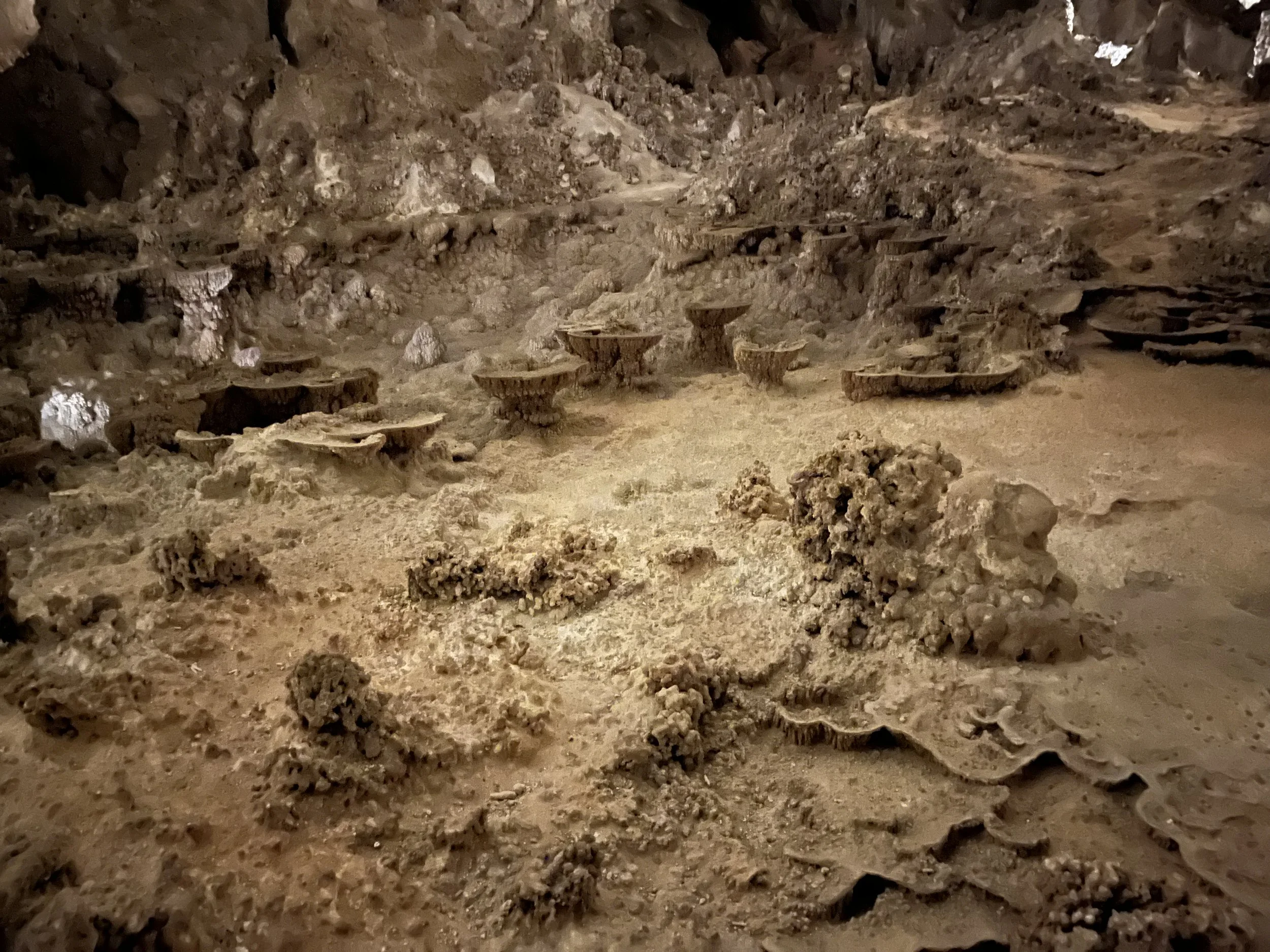
This morning, we went to Carlsbad Caverns. Due to ice, the natural entrance was closed, so we had to take the elevator 750 feet down into the cavern. Cody thought going into the cave via elevator gave it a little bit of a Disney attraction feel. Upon exiting the elevator, we were surrounded by a dark, eerily illuminated underground cave. It was quiet, except for the “drip, drip, drip” sounds of water.
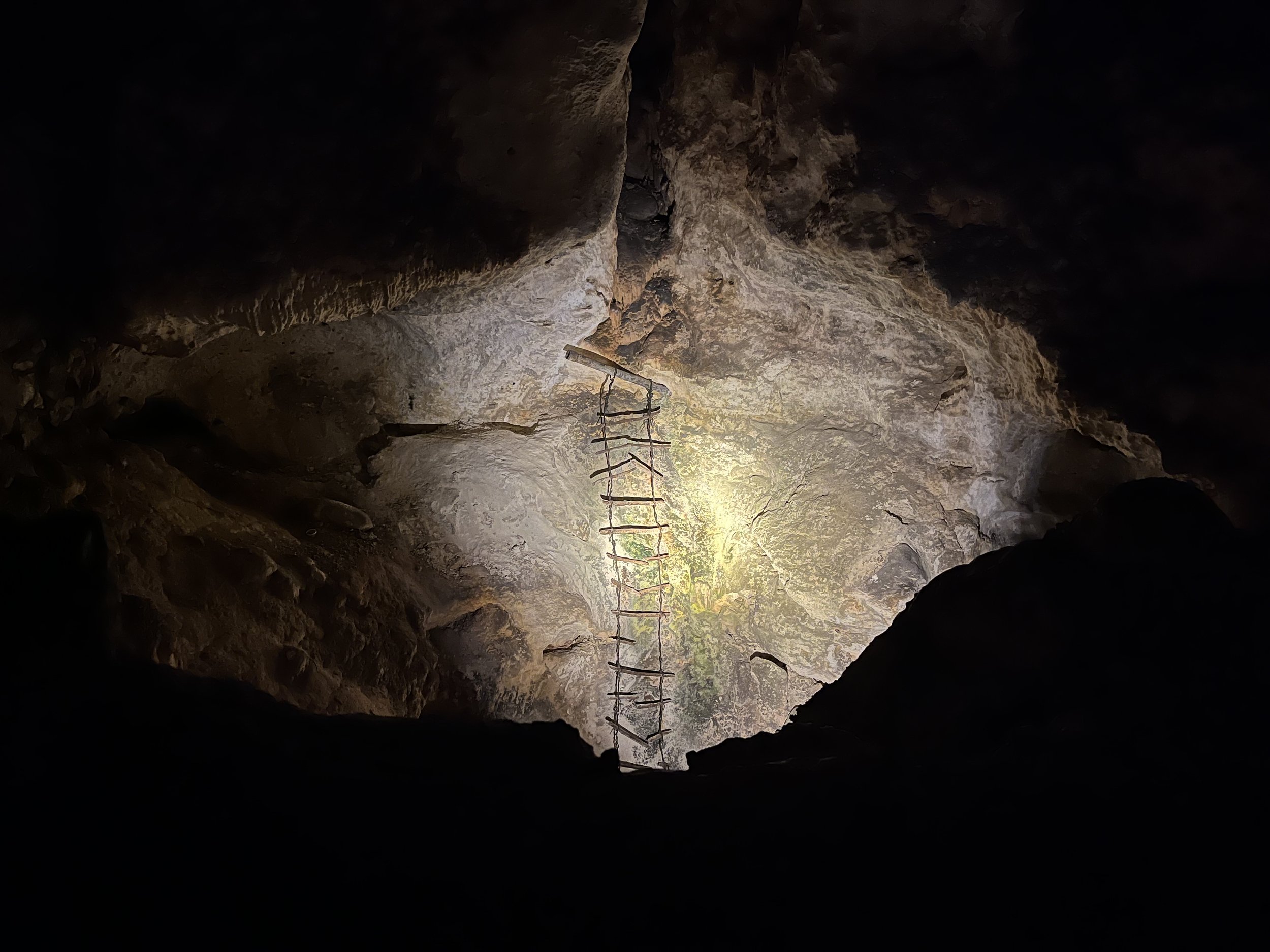
The “Big Room” is the largest single cave chamber by volume in North America (3). Its area is 8 acres, 255 feet tall at its apex, and over 600 feet wide. It really is an impressive sight. It’s easy to forget that you’re so far underground. Various chambers and sections of the caverns have names like the “bottomless pit”, “King’s Palace”, and “spirit world”. The Spirit World was discovered in 1985 and can only be accessed via an opening at the very top of the Big Room 255 feet from the cavern floor. Due to this, very few people have ever been in it.

After our spelunking experience, we went back to the Guadalupe Mountains to hike the Devil’s Hall trail. We ascended a series of switchbacks, until we reached a river wash filled with large boulders. As the trail was not clearly marked, we scrambled over the boulders in a “choose your own adventure” path, relied on our map and followed the snow imprinted footprints of other hikers, until we reached the base of the mountains and entrance to the “hallway.” It looks like the trail ends here, but you can actually climb your way up the shelves of rock and traverse a narrow ledge to continue towards the Devil’s Hall. The Hall is about 15 feet wide, 200 feet long, and has 100 foot tall sheer cliffs rising up on either side as you walk through it. Truly incredible!


Day 4 – Permian Creek trail
Most of Texas is in the Central Time Zone (CST), however the boundary between CST and Mountain Time (MT) is just a few miles south of the park. With this transition happening so nearby, our phones weren’t always updating the time change, making it a bit confusing to know what time it actually was! The gates also close promptly at 5pm, and we didn’t want to get stuck in the park. Eventually we figured out the entire park operated on MT regardless of which time zone it technically was a part of (4).
The weather was warming up, so we decided to tackle a hike at a higher elevation. For us, this meant hiking about 2,300 feet up the Permian Reef trail. The start of the hike was rocky, leading us up to smooth, dark limestone slabs. At some parts of the trail, we had to make a choice between getting poked by cacti, or having unsteady rocky footing on narrow one foot wide paths with steep drop offs. As this was an underwater reef system 250 million years ago, we could see underwater fossils and their imprints all around us. Other than seeing thousands of fossils, the best part of this hike was how peaceful it felt. We didn’t encounter another person on the trail for the entire day!


After our hike, we went back to El Paso. We had dinner at L&J cafe. Our meals were so delicious! I had tampiquena, which was a huge plate of grilled chicken topped with green chiles, onion and tomato, with sides of rice, beans, guacamole, and a cheese enchilada. Cody had a taco salad. (I think the waiter was surprised I had the huge plate of food, while Cody had the salad!) We also had a takeout order of sopapilla, fried dough topped with cinnamon sugar and honey. Although our AirBNB for the night was less than 10 minutes away, we couldn’t wait, and ended up eating them in the parking lot while they were still warm.
Day 5 - White Sands and Pistachio Land
Our AirBNB was a tiny house/shed in the owner’s backyard. It was nicely built, with all the amenities we needed. It was in a great location, close to delicious Mexican food. This morning, we woke up early, drove 2 minutes down the street, and arrived at Gussie’s Bakery as they were opening at 6 am. There was a long glass enclosed case with so many treats. We bought a donut, apple pastry, churro, and guava pastry. My favorite were their tamales! I ordered one with chicken and green chiles, wrapped in corn dough that was steamed in a corn husk. The prices were affordable, with all of these tasty treats totaling $8.30.
Well equipped with our stash of carbohydrates, we were ready to tackle White Sands National Park. The park’s area totals 275 square miles. It is the largest gypsum dune field in the world. Gypsum is the material used in plaster and drywall. Gypsum infused water flows down the mountains, depositing in alkali flats. Selenite crystals form when the water evaporates, and winds from the southwest pick up the gypsum pieces eroding it into soft, fine grain sand, creating waves across the desert. All of this was formed within the last 4000 to 7000 years. The sand dunes are always changing, and move on average 12 to 15 feet a year. The plants do not have it easy here, as they can quickly be swallowed up by the dunes; those that survive are able to grow quickly and scatter their seeds. We did not see any animals, however, many of the species here have adapted to become lighter in color to enhance their chances of survival.
We hiked the Alkali Flats trail in the counterclockwise direction. As you are walking on white sand, there isn’t an exact trail to follow, but there are red trail markers all along the way. Before leaving one, you need to locate the next one, to avoid getting lost in a sea of white sand. It was incredible walking up and down the sand dunes, seeing the sparkling white sand and the ripples made by the wind. It was quiet, calming and otherworldly. It reminded me of walking through meditation labyrinths, except this one was huge with a nearby missile range. This White Sands Missile Range was established after WWII. It was a key location in the development of the atomic bomb (5).


After our hike, we took a trip to Pistachio Land. This attraction was found by Cody when researching pressed penny machines in the area. This was a surprisingly great stop! We saw the world’s largest pistachio statue, standing at 30 feet tall. We ate pistachio samples, and ended up buying some of our favorites, honey garlic and spicy ranch for me, and lemon and margarita for Cody. We also had tasty pistachio ice cream they made on site.
Later in the afternoon, we headed back to the sand dunes to sled! I was scared at first, but it was very fun. We also found a nice spot to watch the sunset. At White Sands, the sun sets behind the mountains overlooking the dunes. It’s beautiful. In the evening, we went back to Gussies for more pastries and tamales!


Day 6 - Traveling home
We woke up early this morning to catch our flight out of El Paso. On my way through security, my bag was flagged for further inspection. Unfortunately, my love of tamales gave me up. The TSA agent gave me a confused look as he pulled out a plastic bag rolled up in a wad from my bag, then chuckled to himself as he realized it was a tamale. I told him it was better than the airport food!
References:
(1) https://www.nps.gov/articles/000/gumo_shiponthedesert_sbtext2022.htm
(2) https://www.nps.gov/places/gumo_guadalupe_peak.htm
(3) https://www.nps.gov/cave/planyourvisit/selfguided_tours.htm
(4) https://www.nps.gov/thingstodo/gumo_whattimeisit.htm
(5) https://www.nps.gov/whsa/learn/historyculture/white-sands-missile-range.htm